Blog · Map skills · October 14, 2026
Map Skills for Kids: Teaching Geography Through Treasure Hunts
The fastest way to teach map skills is to give a kid a map that leads somewhere they care about. Start with left and right and "what's next to what" for ages 3 to 5, add landmarks and a simple key for ages 6 to 8, and bring in compass directions and real places for ages 9 and up. A treasure hunt turns each skill into a job: read the map, walk the route, find the X.
Why treasure maps teach map skills so well
A worksheet asks a kid to read a map. A treasure hunt makes them use one, with their feet, in a room they already know. That changes everything. The couch on the map is the couch they jump on. When they turn the map the wrong way, they walk into the kitchen instead of the hallway, and they figure out why on their own.
The National Geography Standards put this skill first. Standard 1 says a geographically informed person uses maps and spatial thinking to understand and share information. You don't need a curriculum to start on it. You need a map of your house, a small treasure and ten minutes.
Treasure maps also come with the parts of a real map built in: a title, landmarks, a path, a compass rose and an X. Each of those is a lesson you can teach one hunt at a time.
Map skills by age: what to teach first
Kids pick up map skills in stages. Skip ahead and it turns into guessing. Here's a simple order that works at home or in a classroom.
Ages 3 to 5: near, next to, left and right
- Pictures stand for real things. Point at the drawing of the bed, then the real bed. "This is that." That's the first map skill there is.
- Next to, behind, under. "The treasure is next to the big chair." Little kids learn position words faster when they have to act on them.
- Left and right. Put a sticker on their right hand. "Turn to the sticker side at the door."
- Hold the map the right way. Line up the map with the room. If the door is at the bottom of the map, stand with your back to the real door.
Keep it to 3 stops in one or two rooms, and walk the route together.
Ages 6 to 8: landmarks, keys and routes
- Landmarks. A landmark is something you can't miss. On a home map it's the fridge, the stairs or the red rug. Ask your kid to name three landmarks before they set off.
- A map key. Draw a tiny star for "clue here" and a wavy line for "rug." Put the key in a corner of the map.
- Following a route. A dotted line from stop to stop. Have them trace it with a finger first, then walk it.
- Drawing their own. After one hunt, they draw a map of their bedroom for you to follow. Expect it to be wrong in funny ways. That's the learning.
Use 5 or 6 stops across a few rooms.
Ages 9 and up: compass directions, scale and real places
- North, south, east and west. Use a phone compass once to find north in your house, then tape an N on that wall. Now "walk 6 steps east from the couch" means something.
- Scale. "One square on this map is two of your steps." Let them measure and fix the map.
- Real places. Find a real mountain range or desert on a globe, then run a hunt themed around it (more below).
- Let them give the directions. Older kids write the clues for a younger sibling. Writing a clear direction is harder than following one.
Real-place map adventures: the Andes, Sahara, Amazon and Arctic
Spin the globe in My Treasure Map lands on a real place and draws a map of it, with the animals that live there. Finishing one earns a passport stamp. Each place makes a whole geography lesson. Here are four, with something to do off screen after each map is printed.
The Andes Mountains
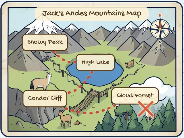
The Andes are the longest mountain range on any continent, running down the west side of South America. The map shows a Snowy Peak, a High Lake, Condor Cliff and a Cloud Forest, with llamas and an Andean condor.
Extension activity: Build the Andes on the living room floor. Pillows are peaks, a blue towel is the lake, and a rope bridge is a belt between two chairs. Hide the treasure in the "cloud forest" under a pile of white sheets. Then find the Andes on a globe and trace them with a finger from top to bottom.
The Sahara Desert
The Sahara in North Africa is the largest hot desert in the world. The map has Giant Dunes, a Palm Oasis, a Rocky Plateau and a Sand Sea, with a camel and a fennec fox.
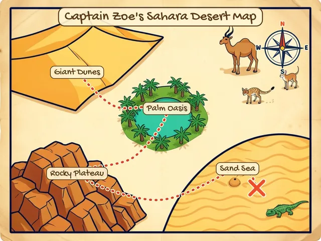
Extension activity: The oasis is the only water for miles. Set up the hunt so every stop is "dry" except one, a cup of water on a plate in the middle of the route. Explorers have to plan a path that passes the oasis. Talk about why desert towns grow up next to water.
The Amazon Rainforest
The Amazon is the largest tropical rainforest in the world. The map shows Giant Lily Pads, a Kapok Tree, a Misty Waterfall and a River Bend, with a jaguar, a toucan, a sloth and a pink river dolphin.
Extension activity: Rainforests have layers. Hide one clue on the floor (the forest floor), one at waist height (the understory), one up high where a grown-up can reach (the canopy). Your kid sorts the animals by where they'd live. Sloths go up top.
The Arctic
On the Arctic Ice map you'll find Ice Floes, a Snow Den, Iceberg Bay and a Frozen Ridge, with a polar bear, a walrus, a narwhal and an arctic fox. Polar bears hunt seals from the sea ice, which is why the ice matters so much to them.
Extension activity: Freeze a small toy in a bowl of water overnight. The treasure is "trapped in the ice." The map leads to the freezer, and the last job is melting it out with warm (not hot) water. Then find the Arctic at the very top of a globe.
Want the map done for you? My Treasure Map draws a brand-new map with your explorer's name on it, from a real place on the globe or one of six worlds. Add a compass rose and a dotted trail, then print.
Want to try a map first? Enter your email at the free day pass page and we'll email you a link to start: 3 maps, free for 24 hours.
See passesHow to run a map-skills treasure hunt at home or in class
- Pick one skill. Left and right, landmarks or compass directions. One per hunt.
- Print or draw the map. Mark 3 to 6 stops and an X.
- Add the skill to the clues. "Turn right at the fridge." "Walk to the landmark with four legs." "Go 5 steps north."
- Have them orient the map before they move. Ask, "Which way is the door on the map?"
- Hide the treasure. Stickers, a book, a passport stamp drawn on their hand.
- Debrief for two minutes. "Where did the map help most? Where was it confusing?"
For a classroom, split kids into crews of 3 or 4, one map per crew, and give each crew a different X.
Printable map-skills checklist
Copy this, print it, and tick a box each time your explorer does it on their own.
Little explorer (3 to 5)
- Points to a picture on the map and finds the real thing
- Follows "next to," "under" and "behind"
- Turns left and right when asked
- Holds the map so it matches the room
Brave explorer (6 to 8)
- Names three landmarks on the map
- Reads a map key
- Follows a dotted route from start to X
- Draws a map of one room that someone else can follow
Legend explorer (9 and up)
- Finds north in the house
- Follows "walk 5 steps east"
- Uses a simple scale (one square = two steps)
- Finds a real place on a globe and names the continent
- Writes clues a younger kid can follow
Safety notes for hunts at home
Keep stops for little kids away from stairs, the stove, windows and water. If the treasure is small, like candy or tiny toys, keep it away from kids under 4. In a classroom, mark any off-limits areas on the map with a big red line. Kids love a "no-go zone."
Make it their map
Pick a real place with Spin the globe, print the map with your explorer's name on it, and send them off with a compass. Each finished map adds a stamp to their passport, so geography turns into a collection. See passes.
For more ways to fit hunts to age, see Treasure hunts by age. For a stuck-indoors day, try our indoor treasure hunt ideas. And if your crew wants clues, the Halloween treasure hunt clues work as a template any time of year.
Questions from grown-ups
What age should kids start learning map skills?
Kids as young as 3 can start with picture maps of one room and words like "next to" and "under." Compass directions work better from about age 8 or 9.
How do you teach compass directions to kids?
Find north once with a phone compass and tape an N on that wall. Then give directions like "walk 5 steps east" during a treasure hunt so the words mean real steps.
What are the parts of a map kids should know?
A title, landmarks, a key, a route, a compass rose and a scale. A treasure map has most of these built in, which makes it a good first map.
Can I use treasure hunts for homeschool geography?
Yes. Pair each hunt with a real place on a globe, then add a short activity about that place, like building a desert oasis or a layered rainforest.
Sources
- National Geographic Society, National Geography Standards, Standard 1 educator guide (maps and spatial thinking): education.nationalgeographic.org
- Guinness World Records, "Longest continental mountain range" (the Andes): guinnessworldrecords.com
- Guinness World Records, "Largest hot desert" (the Sahara): guinnessworldrecords.com
- WWF Canada, "7 things you want to know about the Amazon" (largest tropical rainforest): wwf.ca
- Polar Bears International, "Hunting" (polar bears hunt seals from sea ice): polarbearsinternational.org
- App places list, `public/places.js` (landmarks and animals for each Spin the globe place, checked Oct 17, 2026)